Thursday, July 30, 2009

Heading West

On Tuesday, we left central PA to begin the long journey back West. We decided to go by way of Maryland. Although this might sound a little strange, it really made a lot of sense. We jumped on I70 in Hagerstown, then I68 in Hancock. Driving across the northern edge of Maryland we had the benefit of nice interstates and the beauty of gorgeous rolling hills. I know a lot of RVers say they would rather take the back roads, but I say you see the same scenery on the interstates without the narrow twisty roads. And after the roads that Ron has driven in WV and PA, I think he appreciates the highways too.

Just west of Hancock, I68 goes through the Sideling Hill Road Cut. About 10 million tons of rock were cut out of Sideling Hill, crushed, and used to make the road bed leading to the cut. The 340 foot vertical cut reveals a 350 million year old section of rock which was folded by a massive compression of the Earth's crust 245 million years ago. What we found interesting was how the fold seems upside down. It even rates its own visitor center.


We decided to stay at a Corps of Engineers campground at Lake Youghiogheny which straddles the PA/MD line. This involved some of those narrow, steep, twisty roads, but Ron was game. It was very nice once we made it and conveniently located near Frank Lloyd Wright's Fallingwater which I wanted to tour. Unfortunately the house is closed on Wednesday so we had to wait a day, but never fear, we can always find something to do.

Wow! We discovered we were very close to the Great Allegheny Passage - a 150 mile system of biking/hiking trails that will connect Cumberland, MD and Pittsburgh, PA when completed. We thought, "We'll bike some of it!"

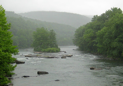
Well, Wednesday turned out to be a complete washout with more periods of rain than not. We did run over to Ohiopyle State Park where we saw the trail that runs along the Youghiogheny River.

I took this of the river between rain showers.

Ron did find the park's 40 foot waterfall called Cucumber Falls (well, at least it's pronounceable.)


Finally Thursday dawned cloudy, but rain-free, and we took off for our 1:00 tour of Fallingwater. (You do have to make reservations or wait for openings. The wait time when we arrived was an hour.) Fallingwater, architect Frank Lloyd Wright's most famous work, was built in 1935 for Pittsburgh department store owner Edgar J. Kaufmann. Wright designed the house to blend in with nature. Instead of facing the waterfall, the house actually rises above it. Wright included walls of windows to blur the edge between indoors and out and cantilevered decks out from the stone building.

Here our tour group catches our first sight of the house.

Pictures are not allowed inside (well, unless you pay more,) so I have none. The house surprised me with its modest size and built-in furniture, which is original. Of course, all those flying decks make it seem much larger. I won't go on and on, but it really was something to see and our guide was very informed. I highly recommend seeing this unique structure, even at $18 a person.

After the tour, we were allowed to take pictures of the outside. Here you can see the stairs that lead down to the stream. Although the stream is shallow, I could see cooling off in it on a hot summer day. The water is a constant 55 degrees and helps cool the house.


There's a trail that leads to the spot where everybody takes a picture, or as Diana says, the tripod spot. I didn't have a tripod (or a great camera), so this is what I got.

Saturday, July 25, 2009

Skyline Drive

On Wednesday we took the RV (with the car attached) and made our way up Skyline Drive along the ridge of the Appalachian Mountains. Now I know a lot of you are thinking, "Mountains? What mountains?" But I love my Appalachians and have a special love for Skyline Drive. Along the 105 mile drive are 75 overlooks. You gotta love that. And the road is beautifully maintained with lovely stone guardrails at all the strategic places.

We began at mile 105 and headed north. Unfortunately, although we had waited an extra day because of weather problems, the view was still not very clear. I have been on Skyline Drive several times and don't remember experiencing this cloud/fog problem, but I think I was always there in the fall.

The 2178 mile long Appalachian Trail runs along Skyline Drive and crosses the road many times along the way. Right after I took this picture of Ron at one of the overlooks, we met two of those intrepid AT hikers.

Tina and Julie started in early May at the southern end of the trail in Georgia. What I found most impressive was that they were older than I would have expected. Not as old as we are, of course, nobody is that old, but single parents on an incredible adventure. They have a website. If you'd like to read about their trip, click here. They are two very admirable ladies.

The fog was worse in some places than others and you can see why I don't have any good pictures.

Soon we gave up stopping at every overlook and just headed for the campground at mile 80.

We found a great site and, after setting up, decided the fog had dissipated enough to try a hike. We took the car and backtracked a few miles to Blackrock Summit Trailhead. The trail was only a mile round trip and promised 'outstanding views and interesting geology.'

Well, maybe the fog had just fallen. While we were in sunshine, the valley still looked cloudy. But it was a nice little hike and the rock slide was interesting.


Although we saw lots of wildlife in the park - deer, rabbits, turkeys, and even a little bear - this was the only thing that held still for a picture. Isn't he pretty?


Inspired by our little jaunt, we decided to take a 3.4 mile (round trip) hike to Calvary Rocks and Chimney Rock. This turned into more like a 4 mile hike since I led the wrong way for awhile. Ooops.

Along most of the trail, the view looked like this.


But at the end, we hiked around some interesting big rocks although we never did see one that looked like a chimney.


On our return trip, we found this colorful fungus growing on a downed tree.


And these alien looking plants. Any ideas?


We can now say we've hiked a few miles of the Appalachian Trail. This post that I'm holding up is one of their trail markers. Pretty nice, huh? If you look closely, you can see the symbol is an 'A' and a 'T'.

Thursday, July 23, 2009

The Blue and TJ

Last Sunday we made it to Waynesboro, VA and parked at the Moose Lodge for three nights. What a great spot. Besides being very welcoming (as is usual for the lodges,) they had a nice gravel spot for us to park, a view of the mountains, and lunch and dinner every day. Since we are not big drinkers, we like to patronize the lodges by buying meals. The food was good and of course we also showed our appreciation with a donation. Everybody wins.

Waynesboro is located at the south end of Skyline Drive and the north end of the Blue Ridge Parkway. On Monday we took the car and headed out. First we stopped at McDonalds for a free sample iced mocha for me while Ron paid for his regular coffee.

Then we were ready to check out part of the Blue Ridge Parkway. Here I am doing the required pose. As you can see, the skies were threatening.

Soon it started to rain and we gave up on that plan.

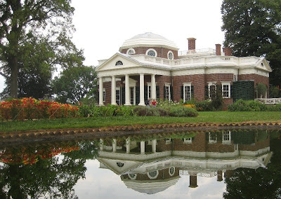
But luckily, we had a backup. Off we went to Charlottesville and Monticello, Thomas Jefferson's home. When we arrived in Charlottesville, it was lunch time and I suggested we stop at McDonalds so I could have (you guessed it) a free iced mocha with my lunch.

We arrived at the visitors center, bought our tickets ($20 now, but for some reason I didn't mind too much), and hopped on the shuttle bus to the house. Everybody knows what Jefferson's house looked like, but did you know he designed it?


We had an hour before our scheduled tour which gave us time to see the grounds. The vegetable garden was particularly impressive - a 1000 foot long terrace cut out of the side of the hill.

Luckily the rain held off until just as our house tour began. Pictures were not allowed, but our guide was wonderful. She's probably given the tour hundreds of times, but you would never think so. I heard one of the other guides say they were paid volunteers which means they aren't paid much, so I guess they do it for the love of Monticello.

We did have to wait in the rain for the return shuttle bus, but then we spent over an hour in the exhibits at the visitors center. Ron had a lot to read.

Wow! I didn't realize Jefferson was so tall!

On our way back to the RV, we made a stop at Walmart. Since it had a McDonalds inside, I thought about another iced mocha, but I decided that was a bit much. Don't forget to get yours - every Monday until August 3.

Sunday, July 19, 2009

West Virginia

We were in West Virginia for the past two nights, which is only one day for sight-seeing. That's certainly not enough time for such a beautiful state with lovely cool temperatures and low humidity. Hopefully we'll see a bit more on our way back West.

After zipping out of Kentucky, we stayed overnight at the St. Albans Municipal City Park (freecampgrounds.com). It was a tiny park right along the Kanawha River and handy for an overnight stop. This was the view out the front of the rig. . .


And this was US60 out the back. As you can imagine it was pretty noisy during the day, but did quiet down at night. And like I said, it was handy, and even offered electric for a donation. (If it had been Monday, I could have walked across the street for a free iced mocha.)


On our way through Charleston, which as we all know from our 5th grade geography is the capital of West Virginia, I was impressed by the dome on the capitol building. (I almost wasn't quick enough to get this shot at 60mph.)


Our goal in WV was to see the New River Gorge National River. I checked on staying in the park, but eliminated it (although it's free) because it was the weekend and the campgrounds were too far off the main road. So thinking I was doing Ron a favor, I suggested we stay at Plum Orchard WMA which was $11 but only 5 miles off the Interstate. Smart, huh?

Well, what we didn't know was how the back roads are constructed in the area. They are basically one lane paved roads with 2-3 feet of gravel on each side for passing. Those five miles seemed like fifty. And we won't even talk about the overhanging trees.

Thankfully once we arrived at the WMA, the campground was fine and only 2/10 mile straight up a hill.

We got some tips on the shortest route to the New River Gorge from the ranger and off we went. Of course this did involve more of the same kind of road, but now we were in the car (and Ron was experienced.)

The sky had an unfriendly gray overcast look, so my pictures could be better, but here goes.

First we hit the north visitor center. I swear they always have the best view from the visitor center and this is it. That's the New River which is anything but new. The most-accepted estimate is that the river has been in its present course for at least 65 million years.


Near the visitor center is the New River Bridge, certainly one of the scariest bridges I've ever crossed. And we did it twice! Although it's plenty wide enough, just knowing that it's 876 feet above the river is enough to give me the chills. How about it, Brenda?

It's also the longest steel single-arch span bridge in the world!

Following the advice of the volunteer in the visitors center, we drove the narrow, twisty road with hairpin turns down into the gorge, across the original bridge and up the other side. Thankfully, somebody had the good sense to make most of it one way. Both of us really enjoyed the trip and watching all the rafters. The New River has rapids that range from class I to V on its way through the gorge.

I told Ron I wanted a shot of both bridges, so we made our way along the river until the bridges were in proper alignment. Then the trees were in the way, so Ron climbed a huge rock and took this for me. Like I always say - What a guy!

We barely had time to drive the loop road around the upper half of the park, including a stop at Babcock State Park to see the Glade Creek Grist Mill. The mill was constructed out of materials from three mills in the state - Stoney Creek, Spring Run, and Onego - and has been on this site since 1976.

The mill is fully operational and I would have loved to see it in action, but the water in Glade Creek was too low.

Friday, July 17, 2009

Daniel Boone

Wrapping up our time with the WINs, we did some hiking in the Daniel Boone National Forest and visited Fort Boonesborough State Park.

Tuesday dawned partly cloudy and only partly humid - not bad. We set out to drive the scenic byway through the Red River Gorge. We all looked longingly at the river, but it was too low for kayaking. It would have been a beautiful paddle.

We took some short hikes along the way. We went through the Angel Windows (at the top of the picture) and found this inviting cave under a rock outcropping.


Here's Will looking through Whistling Arch.

The previous two pictures were expertly taken by Peggy. I shamelessly stole them.

We happened upon a still in the woods. Not that I would know what it was, of course. Somebody told me.


I always say it's a wonder teenaged boys ever make it to adulthood.


We really tied up traffic at this tunnel. It was carved right through the rock in 1910-1911 by a lumber company to use as a railroad tunnel. There are no lights inside and I kept asking if Ron was sure the car lights were on. No place for claustrophobics.

The sign stated, "The tunnel construction claimed the lives of one man and a dog, killed when the man attempted to thaw frozen dynamite by setting it near a fire."

On Thursday, we visited Fort Boonesborough SP, established by Daniel Boone (and others) in 1775. Just look at the gorgeous cabins - I could live in them.

This is a reconstruction, but it's supposed to be realistic. Those of you who know me, know I tend to be skeptical.

They had artisans in period costume who were very interesting and willing to explain all about their craft. My favorite was the loomer? loomist? Hey! That's what I should have asked. Help me out here, Linda.


The spinning lady demonstrated this 'walking wheel', so named because the spinner walks the thread out.


And we saw the blacksmith. For some reason he reminds me of Martin Mull.


I just liked this red wagon and the corn as tall as the sunflowers.


On Wednesday, only the hardiest of the group went on a 5 1/2 mile hike. I was not one of them. Here's the intrepid group minus Peggy who took the picture.

Actually Freddie did her own shorter hike then waited with the cars. I guess I could have done that, but I didn't. In my defense, the weather looked bad. Luckily the rain waited until just after they got home.

Ron seems fascinated by this crevasse. I'm at a loss to come up with an appropriate caption.

(The previous two were also Peggy's pictures and the next one is Ron's.)

This was the view at the far end of their hike. That's half of Double Arch. I accidentally cropped out the other half because I didn't see it. Oops!

And do you know what makes the far mountains blue? It's all the water in the air. The break from humidity was over and it was back with a vengeance.

Today we said our sad goodbyes and left the WINs to look for a drier climate. More on that later.

Monday, July 13, 2009

Natural Bridge State Resort Park

The group has moved about 60 miles southeast of Lexington. We're staying at an RV park where Marvin and Peggy negotiated a good rate for us. Although we are in the town of Slade (population 10?), we are surrounded by the Daniel Boone National Forest and Natural Bridge State Resort Park. Today we visited the park.

First we took the slightly scary ride up the chair lift to the top of the ridge. I found the dismount disconcerting when you had to leap off and run so the chair didn't cut you down at the knees.


Ron looks very much at home on the lift, although a bit cold. Today dawned cool and blessedly not humid. The sky was as blue as it is in Utah.


Here's the group at the overlook. That's Natural Bridge in the background.


Here's a zoomed version.


Walking along the ridge top, we ran into this family who were doing something I found fascinating. The father and four kids (one is out of the picture) are on a trip. They brought along cardboard pictures of the mother and child who couldn't come along so they could be in every picture. I thought that was unbelievably clever and touching.


At the end of the ridge was a spot labeled 'Lover's Leap', where I had to pose.


After walking across the natural bridge, riding the chair back down, and eating lunch, some of the group decided to explore a few of the many trails in the area. Here are Will, Valerie, Ron, Peggy, and Marvin taking a break at one of the trail shelters built by the CCC.


Here's the view from under the natural bridge.


And the stone steps carved through a slot between the rocks that go to the top.


Peggy gracefully navigated this low spot in the trail.


You might have noticed I'm not in any of these pictures.

That's because

I'm

lying

at the bottom

of Lover's Leap.

I guess I got a little too close to the edge.

Happily Ron was able to revive me with a free iced mocha from McDonald's. In case you haven't seen it advertised, McDonald's is giving away free samples of their hot or iced mocha coffee every Monday (7am to 7pm) until August 3. Mark your calendar for next Monday and get yours.