Friday, January 24, 2014

Better

Our house is located in an over-55 community.  The house next door is owned by a woman who is not quite 55 and legally cannot live here.  Several times a year, she visits her house for a couple of weeks.  I know that seems funny, but it works for her and she isn't ready to move here yet anyway.  Micki's a bundle of energy and one day suggested that she and I go for a hike.  Thankfully, she let me pick the hike.

At the north end of Meridian Road is a parking lot that fills up early with hikers who take the 7.5 mile loop around Pass Mountain.  Micki and I arrived late enough that some of those hikers were already back and gone, therefore we had no problem parking.  We hiked part of the Pass Mountain trail up to another of those famous saddles with the great views.  Unlike my last hike, this one was about 4 miles round trip and 650 feet elevation gain.  Much better!

From the parking lot, there's a short (about .3 mile) connector trail to Pass Mountain trail.  Just past the wash is the main trail where we turned north.

We were amazed by all the saguaro cactus in the area.  

This trail was just right for a pleasant day hike.  In a couple of days, Micki would be heading back to the cold Midwest.  I think she really enjoyed it too.

Here's the view from our turn around point at the saddle.  It was prettier than the picture shows.

Just another perfect day here in sunny Arizona.

Friday, January 17, 2014

Fremont Saddle

For our first hike of the new year, we joined up with John and Carol to hike the Peralta Trail as far as Fremont Saddle.  I'll admit this hike didn't seem as hard the last time Ron and I did it.

Even the view from the parking lot is pretty spectacular.

The trail gains 1400 feet in two miles.  I always say 1000 feet in one mile is really steep, so I thought this wouldn't be too terrible.  (I was wrong.)

I'm blaming it on all the rocks we had to climb over because it can't be that I'm older.  I like how the saguaro is pointing the way for Ron in this picture.

This couple carried their twins all the way up.

There was a lot of pretty scenery along the way, which we admired during our frequent rest stops.

John noticed that this rock formation looks like several slices of bread.  I had to agree.

I think we're getting close to the top.

We made it to the saddle with an attrition rate of only 25%.  Here Carol, John, and I are posing in front of Weaver's Needle.  According to legend, the Needle's shadow indicates the location of the Lost Dutchman's Gold Mine.  We didn't search for it.

But I can't leave Ron out and dug up this picture of him from our previous hike in 2010.

Then all we had to do was climb all the way back down where we found Ron well rested in the car.


Saturday, January 4, 2014

Last to Post

About a week ago, we took a nice hike with John and Carol and Jim and Gayle.  Both of them posted about it days ago, in fact, I think Carol posted the same day we hiked.  As usual, I am running behind.  And since we all took the same pictures, these might look familiar.

We all met up in Apache Junction and headed out AZ 88 to First Water Rd., just past Lost Dutchman State Park.  After the longest 2.6 miles ever driven, we reached our parking lot and trail head.

We followed the pretty Dutchman's Trail though some colorful desert landscape.

It's always fun to see water in the desert and we all were prepared to record any slips during the crossing.

Here's the crew at our turnaround point, 1.7 miles out by Jim's calculations.  Although Gayle and Jim were just getting warmed up, they returned with the group.

It really is an interesting hike, much of it in view of First Water Creek.  We'll have to hike this sometime after a rain.


Wednesday, January 1, 2014

2013 Year in Review

Once again I put together a calendar of my favorite pictures from our travels during the past year.  I thought I would just post the pictures I used, but in order to make this a 'year in review', I'll have to add a few other pictures.  This could get pretty long, so I apologize in advance.

We began our travels in March when we joined Diana and Phil on a trip to Hawaii.  We had an amazing cruise around the islands, then an additonal week on the Big Island near Kona.  Phil took this picture of us at Rainbow Falls, which we used as our Christmas card and our new blog picture.

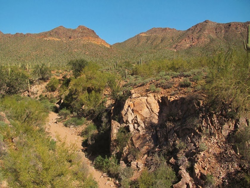
Our RVing adventures began the end of April when we departed Mesa for southeastern Arizona.  I was excited to spend some time hiking in Chiricahua National Monument.

We made our way east to New Mexico, then north on I25, staying at some of the state parks along the way.  Tent Rocks National Monument is well worth a visit.

Continuing north, we enjoyed some gorgeous Colorado scenery and some time with family in Denver.  We found a perfect spot in a National Forest campground where we stayed the two week limit.  The campground was close to this quintessential mountain cabin . . .

And the Chapel on the Rock.

We took day trips into and around Rocky Mountain National Park, but our highlight was seeing the elk calves on the golf course in Estes Park.  They were just a few days old.

We continued north and enjoyed an Escapees rally in Gillette, Wyoming and explored the Bighorn Mountains outside of Sheridan.

The lupine were in full bloom.
 

On we went through Montana, stopping at Little Bighorn National Monument, Billings, Bozeman, Canyon Ferry Lake, and Great Falls, before meeting up with Diana in Glacier National Park.  She took us on a great hike in the Many Glacier area of the park.

And I had to get the famous shot of Wild Goose Island in St. Mary Lake.

We spent time with our WIN friends in Kalispell and Coeur d'Alene, Idaho with its beautiful lake.
.
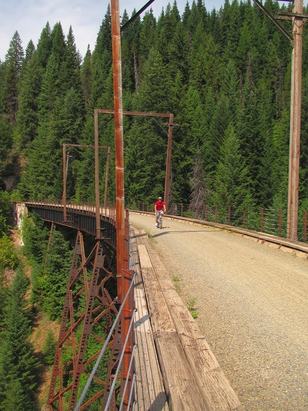
And joined them to bike the Hiawatha Trail on the border of Idaho and Montana.  With its tunnels and trestles, this is an amazing 'rails-to-trails' route.

Leaving our friends, we headed south through Idaho and into central Oregon.  We finally made it to one unit of John Day Fossil Beds National Monument.  In addition to fossils, the monument has colorful geologic features.

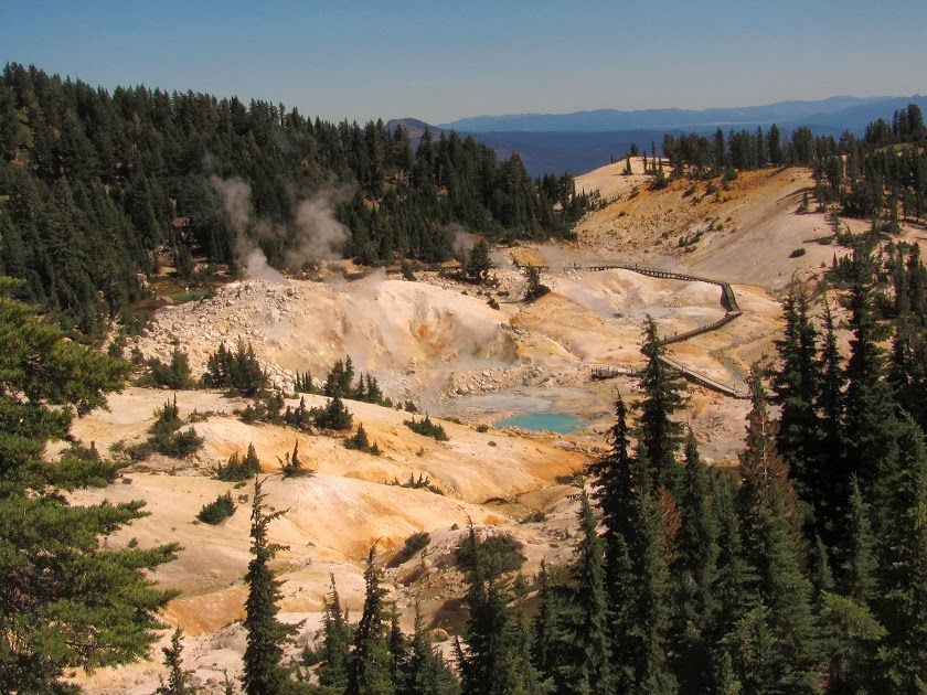
Then we turned south along the eastern side of California.  We enjoyed a day at Lassen Volcanic National Park.

After meeting back up with Diana and Phil, we headed down US395.  We visited Bodie State Historic Park, one of my father's favorite places.

We stayed for several days near spooky-looking Mono Lake.

US395 runs along the eastern side of the Sierra Nevada Mountains with lots of gorgeous hikes and National Forest campgrounds.  Unfortunately, the government shutdown shut us out of the campgrounds and we didn't spend as much time as we would have liked.

We were searching for that nice autumn color, but it was rather scarce.

But the Alabama Hills in the foothills outside of Lone Pine are always fun.

We drove through Death Valley on our way back to Arizona, but couldn't stop and explore because of the shutdown.  That was really unfortunate because the weather was perfect.  How many times does that happen in Death Valley?

We arrived back in Mesa the end of October having put 5168 miles on the RV.  Ron figures we spent $3734 on gas and $916.50 in overnight fees.  Yikes!  This is why I never add these things up!