Tuesday, September 30, 2008

More WIN Fun

Last week while we were with the WINs here in Moab, we were so busy that I have to do another posting to catch up. WIN gatherings can just be exhausting and the one in Moab was no exception. Here are a few more pictures from our time together.

One day, some of us hiked up to Delicate Arch. I know the arch is an evening shot, but we enjoyed the hike anyway. It was really windy, but at least that kept us from getting too hot. Pictured are (from left) Jack, Mary, Claudia, Bob, Ron, with Me and Dodie in the front.


Ron did the 'scare the children pose' in the famous Utah landmark.


One day a lot of the group went kayaking on the Colorado. They paddled from about 10 miles upstream to our group campground.


Here are Ron and I think that's Bill in the back. Something tells me one of them is going the wrong way.


And John is looking pretty comfortable with his feet up - does he think he's in a recliner?


One evening Brenda provided the fixings for s'mores - marshmallows, chocolate, and graham crackers. Yummy! Thanks Brenda. Joey and Ron look happy toasting their perfect marshmallows.


The group did a second 4-wheel drive trip. This time I rode with Max. Here he decided to go his own way down this rough spot. It was pretty exciting.


We passed Gooney Bird Rock. I can see it!


At one point, we passed a whole group of jeeps coming out. I noticed they all had bigger tires. John is talking about raising his Grand Cherokee four inches and getting bigger tires. I wonder how that will look?


When we reached our destination, we all lined up for a group shot in front of Gemini Bridges (upper left of picture.) It's a set of two bridges with about three feet between them. You can't see it in this picture and when we went up top to look at it, I couldn't get a good picture either.


One evening, Bill cooked steaks for everybody - just look at all that meat on the grill. Bill's a great cook and of course we all brought something to share.


We had quite a crowd at the gathering and Kay did a great job as host.

Sunday, September 28, 2008

Arches and Bridges

Arches National Park and the surrounding area contain all shapes and sizes of arches - big, little, high, low - all created by wind action (helped by moisture that seeped into surface cracks.) These arches are not to be confused with natural bridges which are created by running water. Yesterday Ron and I hiked up Negro Bill Canyon to see Morning Glory Bridge, the sixth-longest rock span in the United States at 243 feet.

The trail was four miles round trip and included seven creek crossings each way. Luckily I brought my hiking sticks or I wouldn't have been able to do it. Ron, however, is sure-footed as a goat.


Once we arrived at our destination, I had no idea how to photograph this huge bridge. It's at the end of a side canyon and close to a cliff face. It was also in the shade, although the surroundings were in the sun. You see my problem.


I finally gave up, but I did like this shot of the bridge reflected in the water that created it.


Here Ron poses next to the tiny stream currently flowing under the bridge. I guess there must have been a lot more water sometime in the past.


Today, Diana, Phil, Ron, and I went into Arches NP and hiked the Devils Garden trail - my favorite hike in the area and, maybe, anywhere. Ron asked why we keep hiking the same trail and I said, "Cause we like it!" He's more an explorer type.

Here the three of them lead the way down the nicely graveled beginning of the trail.


That nice trail goes 8/10 of a mile to Landscape Arch which at 290 feet is considered the longest natural arch in the world. In 1991, a 180-ton slab fell from the right side of the span. In 1995, two more smaller sections fell. You have to wonder if total collapse is imminent - you can see it's smoking in the picture. :-)


Continuing past Landscape Arch, the trail passes nearby Wall Arch, which collapsed during the night in August of this year. Here's what remains.


The Park Service had to move the trail because the debris covered it. It's a good thing it happened at night!

Diana has a great 'before' shot on her Flickr site. To see it click here.

This is my favorite part of the hike. Arches is filled with rock structures called 'fins' which erode into the famous arches. This section of the trail goes over one of those fins - not for those afraid of heights. The view inspires a feeling of wonder and gratitude that such a place exists.


At the end of the second mile is Double O Arch, so named for obvious reasons. We climbed through that lower O to reach the tripod spot (Diana's name for the spot where everybody takes a picture.)


For our return we decided to take the primitive trail which adds a mile. It was a bit more challenging, but we made it. On the way, we took a side trip to Private Arch. (We all agreed that if they wanted to keep it 'private', they shouldn't have put up a sign.) Here Ron climbed up the fin to sit on top of the arch. Didn't he read about Wall Arch?


Here's Diana near the end of the primitive trail. The hardest part was not scrambling over rocks, but the 1/4 mile uphill through deep sand at the end. We were glad to get back to the main trail. I tried to convince everybody we should run around the last corner so all the other people would think we ran the whole way, but nobody would go for it.

Saturday, September 27, 2008

Jet Boat Trip

While we were parked at the Gold Bar group site, a jet boat would speed by on the river several times a day. Every time I saw it, I remarked to anyone standing nearby, "I want to do that." Nobody cared. So after the WINs left, I talked Ron, Diana, and Phil into the trip. I hope everybody enjoyed it as much as I did.

The riverboat company is called Canyonlands by Night and Day because their big draw is a night trip where they shine lights on the red cliffs as the boat drifts along. But we chose their 4-hour trip that leaves from the route 191 bridge north of Moab and heads down the Colorado, past Dead Horse Point, and into Canyonlands. We also thought this would be a cool thing to do on one of the 90 degree days we've been having.

The pretty scenery began immediately.


There was a boat ramp where we stopped to use the facilities. Andrew, our captain and guide said, if we wanted, we could use the 'facilitrees' later. Ron got this shot of our boat (with Diana and I still on it.)


Because of the rock layering, there were places where I swore we were going up or down hill. As you can see, this is a downhill spot.


And although not everyone agrees, I see a pink tint in the clouds from all that red rock.


This is Andrew. At one point, he pulled over to the shore and encouraged us all to take a walk. We weren't too sure if we wanted to do that, since it was nice and cool on the river, but he promised it would be worth it.


He took us to see these petrified logs that are embedded in rock. Since the trees are not native to the area, he said the theory is that they were washed down from the Rocky Mountains in a giant flood and trapped in the mud when it hardened. We're not totally sold on that explanation, but the rock did look like flowing mud and it was very interesting.


Here Diana poses with one of the logs.


Then she led us back to the boat. Diana, are you sure this is the path?


More of the interesting rock formations. . .


And on the way back, the reflections were amazing.


This is to support the theory that the grass is always greener on the other side of the boat (or something like that.)

The tour was a nice mix of fast travel interspersed with times of drifting along while Andrew told us about the sights and the area in general. I was certainly glad I went.

Thursday, September 25, 2008

Corona Arch

Today was the last day of the Moab WIN gathering, but Ron and I are sticking around for a while. It was sad to see everybody leave us, but this area is so wonderful that we needed more time. On the bright side, Diana and Phil are here now so we can hike and tour with them.

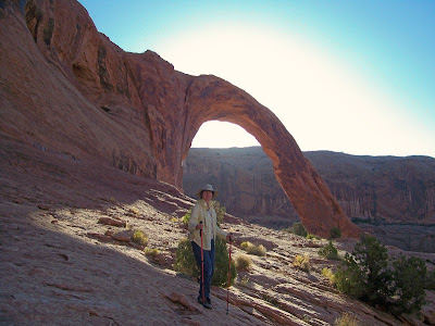
Although I have another posting of WIN activities from the past few days, I'm going to start with today. Right across the street from where the WINs were parked is the trailhead to impressive Corona Arch (140 by 105 foot opening.) One morning, our friend John went up the 1 1/2 mile trail in the dark to get this incredible pre-sunrise shot.


I was inspired to get up early and try my luck, although I drew the line at hiking in the dark. So we climbed up slickrock,


And braved the ladder (alright it was a very short ladder.)


On the way, we stopped to admire Bow Tie Arch - not sure why it's named that.


And reached Corona Arch before the sun hit it. However, it was a real photographic disappointment. . .

I'm not sure even HDR would have helped - I guess to get anything nearly as gorgeous as John's picture, you really do have to climb up in the dark.

So we waited until the arch was in the sun and I took this of Ron with the arch.


As we headed back, Ron did discover why it was named Corona Arch when he turned back and took this picture of me. You can clearly see the sun's corona.


Almost down and another shot of one of the best places the WINs have ever stayed. A lot of them had already left since I believe we had 40 rigs there during the gathering.


To reward ourselves for our early morning exercise, we went to breakfast in Moab. At the Moab diner, we found this picture of a local pilot flying through Corona Arch. I can't imagine somebody being that crazy!

Tuesday, September 23, 2008

Wheee !!

On Sunday, 17 of us took off in six vehicles for a 4-wheeling adventure. Max was our leader and did a fine job of choosing the route and guiding us. I jumped at the chance to ride with John in his Jeep Grand Cherokee. After riding with Phil in his Grand Cherokee on the trip to Crystal (previous post Marble and Crystal,) I recognize it as the Cadillac of 4-wheel vehicles. Instead of coming with us, Ron went to a nice brunch with several of the others (yawn.)

Here we are starting up Long Canyon. The drivers in order are Max, Bertie, Ernie, Bob, John, and Tom behind us. It wasn't as smooth as it looks in this picture since it was pretty rocky, but then it wouldn't be any fun. And it was beautiful.


This dip was a challenge and a couple of the vehicles bottomed out. (Yes, I'm doing that back-seat shooting again.)


Soon it became more difficult as we climbed switchbacks and went through some sandy spots. This natural tunnel was pretty interesting.


But nothing compared to when we ran into this huge truck going down. The driver looked pretty concerned when Bob passed in his Suzuki, but she really got nervous when we went by in John's larger vehicle.


Finally, we reached the road into the north section of Canyonlands National Park. Canyonlands is divided into three sections with the northern one being Island in the Sky. This is a very appropriate name for this broad mesa between the canyons formed by the Colorado and Green Rivers. At the end of the road is Grand View Point Overlook. I really feel the vastness of Canyonlands from this point - it's truly awe inspiring. Unfortunately, it's an early morning or late afternoon picture, not to mention something that can't be captured in a photo.


While there, we broke out the lunches. WINs are always happy when eating.


It struck me in the parking lot how funny we all looked - carrying kayaks on a mesa with no water - even funnier on the 4-wheel trails.


Later at one of our stops, Bob had a problem with his car overheating. Luckily John was able to 'sniff' out the problem.


We did the short hike to Mesa Arch - my favorite spot in this part of Canyonlands. I love how you can take a picture of the formations through the arch.


If my daughter sees this she'll have a heart attack, although maybe she won't realize there's a 1400 foot drop on the other side. Don't tell her.


To get back down off the mesa, we took the Shafer Trail. By means of hairpin turns, this dirt road hugs the canyon wall and descends 1400 feet to the White Rim Mesa, then a more gradual 700 feet to the Colorado River. I have always wanted to do this trail but didn't have the right vehicle. I was very excited. And exciting it was with steep switchbacks and (of course) no guardrails. But I think it's been widened recently. I remember watching a full-sized pickup truck make a 'K' turn to get around the turn. In this picture, Max and Bertie are waiting at one of those turns for a Jeep coming up hill to pass. You can see there is plenty of room.


Here's the other Jeep. You can also see some of the road and one of the turns. It was late afternoon by this time and we were down to three vehicles. Two of them took the paved road home because of time constraints and Bob's Suzuki was sitting at the Visitors Center with a cracked radiator.


We saw these interesting formations along the White Rim Mesa.


Even when we could see the river, we were still about 1 1/2 hours away from home. In all we were gone about 9 hours. My hat's off to Max, Bertie, and John for the fine job they did, but next time I'm going for a shorter trip.