Continuing
south from Big Horn Canyon, we made a quick stop at Thermopolis to view the hot
springs. Although we are not fans of
soaking in hot springs, we do enjoy the colorful terraces created by the
flowing mineral water. We had missed
Mammoth Hot Springs in Yellowstone, so this would be the next best thing.
They
have built up Hot Springs State Park with water slides and pools to encourage
visitors to shell out the bucks, but it’s free to drive in, park, and just walk
around. It wasn’t quite as fantastic as
I had hoped, but the ‘Tepee Fountain’ in the parking lot was pretty
interesting.

The
core was built in 1909 to vent steam from the hot mineral water that was piped
throughout the park. As the water flowed
over the structure, it deposited interesting layers of travertine.
Here’s the original ‘teepee’.

Here’s
a close up. (You can tell I was fascinated.)

We
walked on the boardwalk along the terraces.

We
saw the colorful pool

And
where the mineral water runs into the river.
Cool.

But
the highpoint of my day was the drive through Wind River Canyon. Here’s my shot out the front window as we
entered the canyon.

After
that, I either stuck my camera out the window or Ron pulled into one of the
many pulloffs.
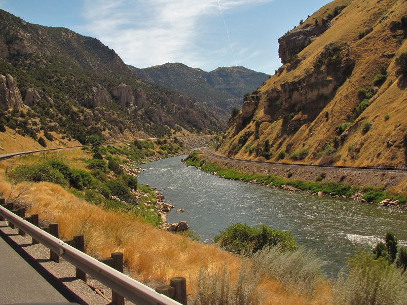

Besides
being a beautiful drive, it’s an optical illusion. The river runs north, but as you drive south through
the canyon, you really feel like you’re going downhill. It’s eerie.

Although
the canyon is Native American land, I’m not sure why these teepees are there. Maybe they're a reminder.

We
saw evidence of landslide activity and later were told it occurred just last
year after unusually heavy rains. It
even closed the railroad tracks.

There
are three tunnels along the way to add to the excitement.

We
stayed the night at Lower Wind River Campground at the narrow south end of the
canyon.

This
was the site of the original dam built in 1908 by Asmus Boysen who had a dream
to provide water and power to Central Wyoming.

The
dam was 180 feet high, 124 feet across and created a lake 14 miles long. Unfortunately, flash floods deposited tons of
silt causing the turbines to shut down and the water to back up behind the
dam. It had to be destroyed. However when the new dam was built a couple
miles upstream in the 1940s, both it and the created lake were named for Mr.
Boysen.


