Wednesday, September 28, 2011

Sights along 101

Sometimes I'm asked how I find all the interesting (at least to me) things to do in an area. Well we stop at state visitor centers, use the AAA book, and take the advice of people who live in or have been to the area. But on the drive down US101 known as the Coastal Highway, it's even easier. Oregon has put together a mile by mile listing of what to see and do along this road. Genius! The following are some of the things we saw between Tillamook (mm 65) and Florence (mm 190) along this very scenic road.

Oregon was very generous when they built viewpoints along the coastal road. It appears they even pay this gull to pose for visitors at one of them.


We saw the world's shortest river, the 'D' river. A whole 120 feet long, it connects Devils Lake to the Bay in Lincoln City.
(Hey, I don't just make these things up - it's in the Guinness Book of Records.)

And Depoe Bay claims to have the world's smallest navigable harbor. It is pretty small, but what amazed me was the entrance to the harbor. How would you like to navigate a boat through this?


This is the view through the gift shop window at Cape Foulweather. The gift shop is the only way to see it.


We didn't stay long at Yaquina Head lighthouse because the flies were sooo annoying. We understand there had just been a hatch.


I quickly snapped another picture from a little farther away. You can see why they needed a lighthouse there.


The same structual engineer, Conde McCullough, designed most (maybe all?) of the bridges on the Oregon coastal road. This is the one in Newport over Yaquina Bay.


Newport was one of our stops and we stayed at the Port of Newport Marina and RV Park. It was expensive at $17.68 a night to boondock in their parking lot, but this was the view out the front window of our rig.


One day we stopped for lunch at a wayside where we read that a short walk would take us to a beach where beachcombers find agates. So Ron and I trotted right on down to see if we could find any. When we arrived at the beach we realized that we don't know what agates look like. Oh well, we just picked up a couple of pretty rocks and were happy.
Since then I googled agates and even saw some in a gift shop although I'm still not sure what they look like unpolished.

We stopped at the Heceta Head lighthouse viewpoint because the book said it was where all the calendar pictures are taken from. See the lighthouse?


Let me crop that for you. As you can see, we have had some fog/clouds along our way.


And at Darlingtonia State Natural Site, you can see these terrific giant carnivorous plants. I wanted Ron to put his hand next to one for size, but he was afraid he could lose a finger.

Monday, September 26, 2011

Oregon Coast Aquarium

I decided the Oregon Coast Aquarium is a misnomer. When the aquarium was mentioned as something to see, I was not enthusiastic. Watching fish swim around in a tank is not at the top of my list of favorite things. But this aquarium is so much more and I'm so glad I went.

First we watched the sea otters being fed. Gosh, do they gulp down the food. And who doesn't love otters.


Then we moved on to the seals and sea lions. These are harbor seals.


And the sea lions seem to know that food is coming.
We learned the most obvious difference between the two is that the sea lions can 'walk' on land while the seals have to just bounce along on their bellies.

Next was the seabird exhibit. These are common murres which, as their name suggests, are very common along the Oregon coast.


But let me skip to my personal favorite, the tufted puffin. Ron and I have a major disagreement on these birds. I think they're the cutest things ever and he thinks they're ugly. What do you think?


I love to watch them 'fly' through the water, but this guy looks like he's standing on top.


I took a short movie of his odd behavior.


There were aquariums, but they had some unique occupants. These are moon jellyfish. Cool, huh?


And I knew I should have written down what this was. I just know it wasn't a jellyfish.


And we were told these are not starfish since they are not fish. They have been renamed sea stars. I swear they weren't this colorful at the Jersey shore.

They also had some big aquariums with lots of fish, but the only ones I recognized were the sharks. The sturgeons were interesting since they're endangered and can grow so big. It was way too dark for my camera, so no pictures. You'll have to go yourself.

The Oregon Coast Aquarium is in Newport, Oregon.

Saturday, September 24, 2011

Out and About

After two days of clouds and rain (well, really, what did we expect in the Northwest?), we were thrilled to finally see the sun. So off we went on the Three Capes Scenic Loop - Cape Meares, Cape Lookout, and Cape Kiwanda.

First up was Cape Meares with its very short lighthouse - only 38 feet tall.


The view from the lighthouse was spectacular, even with the ever present fog on the water.


Continuing to Oceanside, Donna led us to a place she had visited before where, at low tide, you can walk through a tunnel to reach another beach. Here's Jan ready to brave the dark.


It never got completely dark or I wouldn't have done it. This is the view out the other end.


I had to go just a little farther to catch the waves hitting the rocks.
Which might have been pushing my luck since the tide was turning. A rogue wave surprised us and while Jan and Ron dashed up the rocks to higher ground, I ended up with wet feet for the rest of the day. (You know the old joke that if you encounter a bear, you just have to be faster than your hiking partner? Well, I am the person that the bear would catch.)

Unfortunately, Oceanside was actually the end of our loop since the road between Oceanside and Netarts is currently closed. The problem began in March when the road slumped due to heavy rains. At first they were able to keep one lane open, but as the problem escalated the road was closed. Some enterprising person even printed up t-shirts that say 'I survived the Great Divide'.

So we backtracked and went to Munson Creek Falls, just a few miles south of our campground. It's the highest on the Oregon coast at 319 feet, but not too photogenic with all the trees in the way.


But we really loved the short hike to reach the falls. I don't know if it really is a rain forest, but it sure seemed like it to us. I felt that if I stood still too long I would sprout moss.


We stayed very close to the Tillamook Air Museum which is housed in the largest wooden clear-span structure ever built (according to the Guinness Book of Records.) The hanger was built in 1943 to house blimps that were used for anti-submarine coast patrol and convoy escort. Ron toured the museum and although he appreciated the 30 airplanes on display and the information on the blimps, he said the movie showing how they built the structure was the most interesting. He highly recommends it if you're in the area.

I know the hanger doesn't look that big in the picture so I'll give some stats.
Length - 1072 feet
Height - 192 feet
Width - 296 feet
Doors - 120 feet high, six sections each weighing 30 tons, 220 feet wide openings.

Friday, September 23, 2011

Tillamook, OR

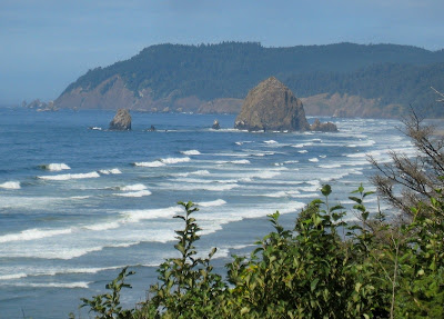
Heading south on US 101, we stopped at the overlook for the most famous of the offshore 'sea stacks', Haystack Rock. Being from the East Coast I am always amazed by the scenic Oregon coast.


We pulled into the campground at the Tillamook Airport and were thrilled to see a herd of Roosevelt Elk. There had to be 60 of them.


What to do . . . Well, a fellow WIN recommended the Pioneer Museum and since it was raining, it sounded like a good idea. They did have some Pioneer displays, although I don't think the organ came in a covered wagon.


And we decided no pioneer woman had enough time on her hands to cut fancy shelf paper out of newspaper.


But on the second floor was an impressive collection of stuffed animals. After looking for them all over the Northwest, I finally got a picture of an American Dipper.


We also never saw any of these guys - thank heaven.


Of course you can't visit Tillamook without touring the Tillamook cheese factory.


But we did one better and also went to the Blue Heron cheese factory. Here's Mary enjoying their sample dips. They put out pretzel sticks and cups of dip - I'm not sure how sanitary that is, but we filled up.

Wednesday, September 21, 2011

Yippee!

Today I received my computer back from HP after its hard drive crash. But what's really amazing is they saved my files, which in my world means my pictures! Wow! I'm doing a happy dance!

Although I'm again behind in the blog, I'm going to backtrack for just one posting to share the pictures I thought I had lost. We had such a wonderful time on Whidbey Island that I just have to do it. Whidbey Island is located in the San Juan Islands in the northwest corner of Washington.

To access Whidbey Island from the north, you drive a narrow double bridge over Deception Pass. Named by George Vancouver in 1792, the 'deception' was that at first he thought the island was a peninsula.


As I mentioned in a previous post (here), we stayed at Rocky Point Recreation Area. You can see how roomy the spaces are.


Here's Ron standing on the Deception Pass bridge. The tidal flow creates whirlpools and swift currents under the bridge, as well as exciting boating opportunities.


We took a day trip to Fort Casey State Park and the Admiralty Lighthouse.


Fort Casey was one of three forts built to defend the Puget Sound in the 1890s. Here's Ron manning one of the big guns.


One day 19 of us took a jet boat tour through Deception Pass.


We had such a good time. True to their promise, they didn't get us all wet. (The jet boats were just to navigate the tricky currents.) The guide was very knowledgeable, although his jokes were a bit too corny. Hey, I like a silly joke just fine, but there's a limit to how silly it should be.


Just look at all these happy faces!


Even the few people on the boat who weren't WINs posed for my picture.


At the end of the day, we walked down to watch the fishermen. It was a fitting farewell to a great place.

Saturday, September 17, 2011

More Astoria

It was another dreary morning when we headed back across the bridge into Washington. Our first stop was a place that Lewis and Clark named Dismal Nitch. The Corps of Discovery was trapped there for six days by raging storms while within sight of the end of their journey. We could easily imagine their frustration.


Next we moved on to Cape Disappointment State Park. I'm seeing a theme here. Am I the only one who thinks this sign is funny?
(Actually Cape Disappointment was named long before Lewis and Clark made their incredible journey. In 1788, British fur trader John Meares named it in frustration over not finding the river channel.)

However in 1805, Cape Disappointment was one of the places that the Lewis and Clark expedition considered for their winter quarters. They took a vote and decided to cross the river into Oregon. The interpretive center at the park chronicles their fantastic journey from St. Louis to the Pacific. Even I spent quite a bit of time reading the signs and examining the exhibits. I highly recommend it.

It did clear up enough that we could see the lighthouse overlooking the Columbia River.


Then we went to see the North Head lighthouse on the Pacific Ocean side of the point. I swear this has to be the shallowest surf ever.


And here's the North Head lighthouse. (Only the first two of many lighthouses to come, I'm sure.)


Back in Astoria, we drove up streets with ridiculously steep grades to the Astoria Column. The 125 foot column stands 635 feet above the Columbia River. And you can climb it, which Ron and I did, making the views even more amazing.


But what I like best about The Column is how it's decorated with scenes depicting the area's history.


It's a good spot to see the 4 mile bridge over the Columbia River joining Oregon and Washington.