Tuesday, May 31, 2016

Salt Lake City

We spent several days around Salt Lake City.  The Wasatch Mountains are just magnificent.

Ron's son Jim lives in the area and it was great to spend some time with him.

Ron wanted to do some genealogy research at the LDS Family History Library.  The Church of Jesus Christ of Latter-day Saints, headquartered in Salt Lake City, has an incredible amount of genealogical information.  Visitors are welcomed with volunteers ready and willing to help with your research.

While Ron was doing that, Diana and I did some sightseeing.  First, we visited the Capitol.

Because it was Saturday, tours were not available.  We could wander around, but the doors to the House, Senate, and Supreme Court were locked.  The Rotunda artwork was funded by the Depression era Public Works of Art Project.

The beehive is Utah's state emblem, symbolic of industry and unity.

I was surprised to see statues of gulls atop the bus stop shelters.  At first I thought maybe it was to keep live gulls away.

But Ron remembered hearing something about the Miracle of the Gulls.  According to Mormonism, in 1848, gulls miraculously saved the crops by eating the swarms of insects that were destroying their fields.

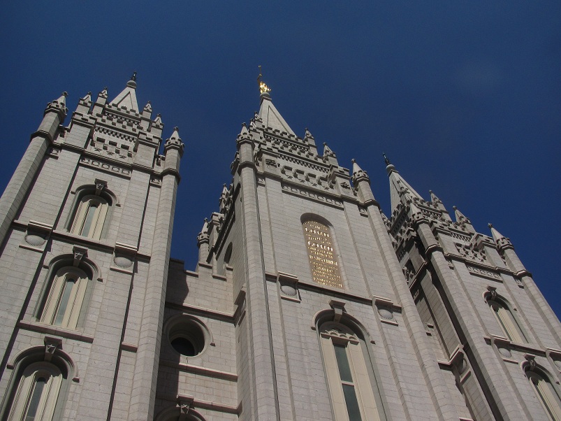
We also visited Temple Square, 35 acres in downtown Salt Lake City.  The actual Temple is off limits to visitors, but most of the other buildings are open.  It's hard to get any pictures of the Temple.  It's huge and surrounded by lots of trees.

The Temple took 40 years to build, from 1853 to 1893.

We checked out the roof garden of the Conference Center.

And saw the Tabernacle, home of the Mormon Tabernacle Choir.

I think my favorite building was Assembly Hall, built in 1882.  How charming!


To complete our stay in the area, we visited Antelope Island.  At 15 miles long and 4.5 miles across, Antelope Island is the largest island in the 17,000 square mile Great Salt Lake.  The lake seems to be unusually low.

Bison were introduced to the island in 1893.  Now they have to thin the herd and sell bison burgers in the concession.

Just look at them all hanging out in the shallow lake.

You can see lots of calves, otherwise known as future burgers.

We got to see a bit of excitement.  We don't know if this coyote was eyeing up one of those babies or just passing through.

But when he got too close, a couple of the bison did stir themselves enough to threaten him.

Don't feel too badly.  Like Diana said, that was one healthy looking coyote.

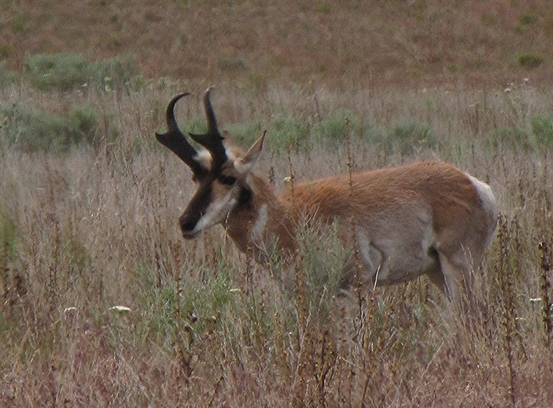
We also saw a few of the island's namesake, the pronghorn.  (Formerly known as antelope.)


Sunday, May 29, 2016

Capitol Reef (part 2)

Diana always drives us on the days when we take the adventurous roads.  So once again, her truck got dirty taking us down Grand Wash Road to the Grand Wash trail.

Looking through a window near the beginning of the trail.

 It's fascinating how the water creates swirls and holes in the sides of the wash.

The trail is 2.2 miles from Grand Wash Road to a parking area on the main road through the park and is pretty open on both ends.

But in the middle, it goes through the Narrows, where the walls close in and tower above.

We went almost to the other end before turning around, remembering to look down as well as up.

On our way back home, we made a stop for a short hike to Sunset Point where we had great views of the Goosenecks.

It wasn't sunset, but still pretty spectacular.

And I snapped another picture of Chimney Rock out the truck window as we drove by.


Friday, May 27, 2016

Capitol Reef

We took the very scenic (and a little scary) Utah 12 from Hole-in-the-Rock Road to Torrey.  Some of this road is known as the Hogback where it runs along a ridge.  I was doing a lot of leaning, but refrained from screaming at Ron to move over.

We moved into a pretty boondocking area just west of Capitol Reef National Park.

Ron and I decided to hike the Chimney Rock Loop Trail - a new one for us.  After going six miles the other day, we thought the 3.6 mile loop would be perfect, even with a 590 foot elevation change.

The climb began almost from the parking lot, although we barely noticed with all the colorful scenery.

But by the time we arrived at the split for the loop trail, we were really huffing.  The right fork looked like it just kept climbing with no end in sight, so we took the left which was more level.

We had a view into what is Chimney Rock Canyon, according to the map.

Where Ron saw a hawk in this rock.  (And he always says he has no imagination.)

But soon we were back to climbing.

With more views of the many pinnacles along the way.

We continued up and up to the top of the mesa where we could see the waterpocket fold cliffs in the distance . . .

And part of the Goosenecks created by Sulphur Creek.

Ironically, the Chimney Rock Loop does not encircle Chimney Rock, but there is one place along the long way down where you can see it.

Whew!  That was more exhausting than I thought it would be, but the good news is that my feet didn't hurt!


Wednesday, May 25, 2016

Lower Calf Creek Falls

Good news for those of you who read both my and my sister's blogs!  One day we did different hikes during our stay in Grand Staircase - Escalante NM.  Amazing, huh?  Ron and I wanted to redo a previous favorite, Lower Calf Creek Falls, and Diana elected to hike . . . well, I'll let her tell you.

Driving out of our boondocking spot, we had to laugh at this sight.

The hike to Lower Calf Creek Falls is three miles (each way) up a beautiful canyon.

This rock outcropping looked like a gargoyle when we passed it, but now I'm thinking Precious from the Hobbit.

The sky was nice and clear for the first half of our hike, but we knew it would cloud up later.

I asked Ron to pose at this spot because it looked familiar.

Sure enough, here we are in 2009 when Diana took our picture at the same spot.
(No, my memory isn't that good.  This picture is in a collage at home.)

These plants looked like tiny bouquets in the sand.

Onward . . .

At one point, we could see that beaver had been hard at work in Calf Creek.

I was intrigued by this alcove across the way.  It's a lot bigger than it looks in the picture.
I also really like the dark streaks of desert varnish.  It looks like somebody went nuts with a paintbrush.

The last mile before the falls is more shady and right along pretty Calf Creek.

In one section, we noticed the trees had been denuded.

Aha!  Here's one of the culprits.

Just when we were beginning to think they must have moved the waterfall, there it was over the treetops.

Lower Calf Creek Falls is 126 feet of stunning beauty.

Sure enough, the clouds moved in on the way back to keep us cool and we just beat the rain to the car.  It was a perfect day!  We both survived the six miles in good shape except for the soles of my feet.  They were killing me!  Does this mean I'm a tenderfoot?