Saturday, July 30, 2011

Mt. Bachelor

One day some of us took the ski lift halfway up Mt. Bachelor to Pine Marten Lodge at 7,775 feet. I wish you could ride up backwards since turning around to watch the scenery was hard on my neck.

The parking lot looks pretty far down there, with Broken Top looming in the background.


Here come Carolyn, Paul, and Marian right behind us.


View of the Three Sisters and Broken Top from the top of the lift.

We were lucky to be there in time for a talk by a forest ranger. He was very interesting and because we had been to so many of the surrounding sights, we knew the answers to all his questions. At one point he turned his hat over to me.

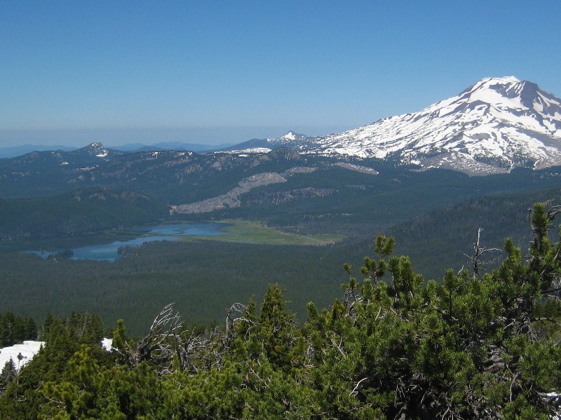
One thing we didn't know, was that Sparks Lake, nestled here at the base of South Sister, is disappearing. See the green meadow to the right of the lake? It used to be part of the lake. Not only does the lake level drop during the summer, but it drops more each year. There are what he called sinkholes that are draining the water. He said you can even hear it draining. That's when I decided I had to go back to Sparks Lake.

But first, at the base of the ski lift, Rachel Scdoris, four time Iditarod Musher, and her father - trainer, Jerry Scdoris - offer dog sled rides for a nominal fee. If they had actually pulled you in a sled, I would have been first in line. However, it was more like an ATV, so I wasn't interested. But Rachel and her father were very nice and talked to us for quite a while.

They said the dogs are called Alaskan Huskies which I think means any kind of dog mixture that just loves to run. They did all look kind of similar, which makes sense since Rachel and Jerry raise and train their own dogs.


This little one is one of her best leaders. I guess size doesn't matter.


Then off we went to revisit Sparks Lake. What makes Sparks so unusual and scenic is all the lava that surrounds and is part of the lake.


We hiked along the lakeshore and, sure enough, we did hear the water draining out! It sounded like water going through a culvert, but there was no culvert. Cool!


So if you want to see this beautiful lake, hurry before it's gone.

Thursday, July 28, 2011

Cascade Lakes

We moved up to a sno park located about 15 miles west of Bend. The sno parks are used primarily in the winter for snow mobiles, cross-country skiing, sledding, and even dog sledding. But in the summer, RVs are welcome to stay. Wanoga sno park is conveniently located along the Cascade Lakes National Scenic Byway at a cool 5500 feet. The obvious activity from here is to tour the lakes along the scenic byway. So yesterday Ron and I made the trip.

Our first stop was Sparks Lake. This lake was the favorite of Ray Atkeson, Oregon's photographer laureate, and a short trail leads to some amazing views. That's South Sister in the background.


There go some of our WIN friends kayaking the lake with Broken Top peeking over the trees.


Although Sparks is the most picturesque of the lakes, we found something interesting at each one. At Elk Lake we found this little 'Tom Sawyer' poling his homemade raft. Of course his girlfriend 'Becky' was riding along.


We watched a flock of Mergansers swimming and diving on Lava Lake.


And at Little Lava Lake, we spotted this tiny duck with her precious brood.

We also had a great lunch at the restaurant at Cultus Lake while we watched the kids, young and old, playing in the lake. It was another gorgeous day.

Saturday, July 23, 2011

Bend, Oregon

(Second try - I hit the wrong button.)

Bend is a very nice place. With 80,000 people, it is just the right size. They have all the important stores - like Trader Joe's, Costco, and outlet stores, but surprisingly the downtown is booming. We drove through the other day and I think every parking spot was taken. That's nice to see.

Although I've been neglecting the blog, we have been busy here. We're parked on National Forest land conveniently located just about four miles from downtown.

Here's the view out the front of the RV. Oh, look! It's Ron filling in the windshield crack so it won't get any bigger. He did this a few years ago on the same crack, but it recently started to run again.


On to our various activities. One day we took the bikes for a ride along the Deschutes River. Pretty and flat - my kind of ride.


We went to the High Desert Museum. They had a sawmill from the early 1900s that was not running, but having Ben (in period costume) tell us about the workings and history almost made up for it. He said all the boards for the surrounding pioneer building reconstructions were cut by this sawmill. They would love to run it every day, but the guys with the know how are getting old and are not available. They need to pass on that knowledge to the 50-year-old youngsters.


I liked this diorama of western life on the trail.


They had some animals that were unable to be released into the wild. I think the otter was depressed because he was lonely. He did come out and do a lap for us though.


And very exciting! I got to see a salmon jumping upstream. (Okay, he was a bit metallic.)
The museum had lots more to see and was reasonably priced.

Another day we went to Tumalo Falls. How gorgeous! It reminded us of Lower Yellowstone Falls, but without the yellow cliffs.


Here's a closer view.


Just look at the power of this waterfall!


By following the trail for a couple miles, you can see two other impressive falls.


This picture is actually the upper part of the previous one. The other waterfall was through the trees so I didn't get a decent picture.


If you are really observant, you might see this undernourished elephant along the way.


Another day I made up for my previous failure to climb to the top of the cinder cone in Lassen NP. In the northern part of Newberry Crater National Monument, they have one you can DRIVE up!


Here's the view into the center of a cinder cone. I'm glad I didn't go to too much trouble. I was expecting it to be deeper.

Sunday, July 17, 2011

La Pine

La Pine, Oregon, is a nice little town with a great attitude towards RVers. The Moose Lodge and American Legion both welcome RVers and have available hookups, the local truck stop has a dump, and even the Dairy Queen has RV parking. But the best thing about La Pine is there are NO mosquitoes. We settled in at the Moose for four nights. Funny thing, fellow WINs Janet and Doug happened to stop at the American Legion, so we had some fun with them too.

We visited a couple of volcanoes nearby. The first was a strange looking formation called Fort Rock because of its appearance.


It's the remains of an ancient underwater volcano and in more recent times was surrounded by water and used by the Native Americans.


Now it's surrounded by farmland. It looks even more like a fort from this angle.


Then we went to Newberry Crater National Monument. Like Crater Lake, this was a huge mountain that erupted and collapsed. There is a road to the top of Mt. Paulina which is actually part of the rim of the caldera, but once again, the road was closed with snow! But we did a short hike that climbed to a vantage point and we could see pretty Lake Paulina.


Okay, I'm guessing phlox.


I was really excited to hear they have an obsidian lava flow. Obsidian contains a high percentage of silica, the primary ingredient in glass. Native Americans used obsidian for arrowheads and tools because of its sharp fracture lines.
Ron is standing next to a large piece of obsidian. The flow as actually a mixture of obsidian and pumice, the difference being the pumice cooled with bubbles in the rock.

This one I know is penstemon, growing bravely among the lava flow.


Back down at lake level, it doesn't look nearly as colorful. Where Crater Lake has one big lake with an island, Newberry Crater has two lakes separated by the cinder cone you see in the distance.


And more waterfalls! Paulina Creek splits into a pretty double waterfall.


Here's another shot from below.

Friday, July 15, 2011

Great Bike Ride

The Dellenback Bike Path is an 11.5 mile paved trail around Diamond Lake. It is mostly level and rated easy, but I'm really not much of a cyclist. We were staying at the south end of the lake in Broken Arrow CG which has connecting trails to the bike path. I suggested we go clockwise around the lake with the thought that we would be most of the way around when we passed through the resort area with a cafe where I could refuel for the rest of the trip. Pretty smart, huh?

So off we went confident that our blazing speed would keep us ahead of the hungry mosquitoes.


For the most part, that worked, but I did take a risk stopping to take pictures.


Mt. Thielsen is on the east side of Diamond Lake. The lightning rod spire at the top is a volcanic core that was worn down by glaciers.


Here are Thielsen and the Sawtooths - sounds like a musical group, doesn't it?


And to the west of the lake is Mt. Bailey, also formed by volcanic action, but looking very different.

It was really a lovely ride although we did hit some swarms of tiny flying bugs. It reminded me to keep my mouth shut. During this stretch, I heard a young girl forcefully say to her parents, "Next time we WILL take the car!" I had to laugh. Kids!

And yes, we did stop at the cafe, but I only had iced coffee while Ron had a sundae!

Wednesday, July 13, 2011

Oregon Waterfalls

Continuing north, we settled around Diamond Lake, just north of Crater Lake. This is a wonderful area with plenty of natural beauty and ways to enjoy it. However the mosquitoes have gotten increasing worse with each move and we are forced to take bold action.

One day we decided to drive scenic OR138 which follows the North Umpqua River, stopping at some of the numerous waterfalls along the way.

Ron came prepared for the hungry wildlife.


The first waterfall we visited was Watson Falls. A short hike took us along pretty Watson Creek . .


To Watson Falls which plunges 272 feet over the edge of a basalt lava flow.


I enjoyed the rhododendron blooming along the trail.


Next up was Toketee Falls - one of the most photographed along the route. This was obviously the wrong time of day. I actually thought this was the worst waterfall picture I would take all day, but I was wrong.


The drive between the falls was gorgeous and deserved a picture too. For some reason, this is called Rattlesnake Rock.


Now on to the worst picture. It started out well with this pretty trail.


Tragically Susan Creek Falls was in full sun with all the surrounding area in deep shade. But in the spirit of full disclosure, I'm posting the picture anyway.


On our way home, I decided to try Toketee Falls again. Either I was still too early (at 5pm) or the picture should be taken before the sun hits it in the morning.


So here is one of the voracious critters trying her best to attack. Actually, mosquitoes are not my most hated insect. The tiny black flies in UP of Michigan and the ticks in Arkansas are worse in my opinion. Luckily it's been cool enough that we can cover up (Ron has his bee keeper suit and I have my Avon bug guard.)

Monday, July 11, 2011

Change of Pace

Since we were in a campground right across the street, we decided to visit the Collier Logging Museum in Chiloquin, OR. They had an amazing amount of logging equipment plus lots of other old stuff. Not really my thing. Now if the equipment had been operational and they were demonstrating how it worked, that would be cool. But just to see it lying around didn't really impress me. However in an effort to pretend to be well rounded, I'll do a post on it.

There were a couple of big saw thingies that I'm sure were very dangerous to operate.


Ron was very impressed by this Beloit Tree Harvestor.


With its arm thingy, it could delimb a 62 foot tree and shear a 24 inch tree off at the base.


I did kind of like this other thingy with all the wheels.


And the real log outhouse.


But soon I was wondering aimlessly looking for things I could understand. I found some rusty stuff for Diana.


And a locomotive for my father. (It was in with lots of other stuff, so I couldn't get a very good picture, but I'm hoping it's interesting.)


I'll even throw in the sign for this 'G.O.P.' engine.


I like the colors of the creek (this would be a river back east.) Who needs to go to Tahiti?


And look at the fine logging boots carved out of a log - how appropriate.

All kidding aside, it really was an impressive collection and maybe we should have come for the Saturday afternoon tour and learned something. One thing I do know, logging is a tough job and I wouldn't want to do it.