Tuesday, May 20, 2014

Petrified Forest NP

Somehow I got really behind on my blog, but I'm trying to catch up.  I just don't know how that always happens.  Our next event was re-visiting Petrified Forest National Park.  I don't care how many times we see it, it always impresses.

We stayed a night at the gift shop just outside the southern end of the park.  They graciously allow RVers to park overnight for free.  Of course, common courtesy requires a visit inside and they have many lovely things to see.

Humm, I wonder if we're supposed to stay in the tepee.

Since we had just been there two years ago, we skipped some of the more popular stops and hit some others.

Funny story - The first time I visited Petrified Forest, I expected to see whole forests of trees, still standing and turned to stone.  Well, in case anybody else thought the same, the trees are in pieces and scattered all around, but sometimes you can find a whole trunk lying together.

Our first previously skipped stop was Jasper Forest.  The most notable fact about Jasper Forest is that it was so stripped of its petrified wood that there is hardly any left.  There is some at the base of this mound which had probably been hiding under the cap rock before it fell.

Our next stop was Blue Mesa and an exception to my previous statement.  We had stopped there in 2012 but didn't have the time (or energy) to take the one-mile trail down into the colorful hills.  I wanted to do that. Pictures can only give a hint of how beautiful it is.

When I reached the bottom, it took my breath away.  (Or was that on the way back up?)

Here's a log balanced on top of an eroding pedestal.  When I come back in 50 years, it will be on the ground.

After puffing my way back to the top, I spotted this pretty Indian Paintbrush, or maybe Desert Paintbrush. And is that Kermit the Frog on the right?

The colorful layers are even more pronounced in the Tepees which are right along the main road.

The next stop was Newspaper Rock.  At first it didn't look like much.

But if you zoom in, you can see how it got its name.

And we stopped at Puerco Pueblo - a partially excavated pueblo built around 1250.

There were a lot of petroglyphs there also, including this obvious ibis with a frog in its mouth.

Then it was on to the Painted Desert section of the park.

The colors are fantastic, but I know the pictures would be much more dramatic when the sun is lower in the sky.  We'll have to stay near the north end of the park for that to happen.

Looking over this post, I realize we shipped over all the gorgeous petrified wood stops, so if you are interested in seeing some from our last visit, including Agate House and Crystal Forest, click here. I have to warn you that a couple of the pictures from then look identical to the ones here.  I guess that shows I'm not too original.

After exiting Petrified Forest NP, we headed into New Mexico with a stop at Window Rock on the way.

The statue immortalizes the Navajo Code Talkers who were so valuable during World War II.  If you're not familiar with their contribution, click on the sign.  It's a fascinating story.


Monday, May 19, 2014

Town Fix

Ron and I are both country mice and city mice.  We enjoy our time off the beaten path, but also need a city fix every so often.  Show Low, Arizona, is a sweet place, surrounded by national forest.  We stayed in Lakeside CG, a national forest campground right on 260, the main road from Show Low to Pinetop/Lakeside. Perfect.

We got to catch up with friends Jon and Patrica, and had a couple good meals and lots of laughs with Mary Ellen and Ted, all of whom live at least part time in the area.  We hit a few thrift stores, one of my hobbies, replenished our food supplies and did laundry.

But we also took a couple or hikes that I found on my phone.  Yes, Virginia, there's an app for that.  Probably more than one, but I use AllTrails.  It's pretty cool.  You can read others' comments and ratings and leave your own.  We picked two to try.

The first was the Ice Cave Trail, an easy four-mile round trip.  The trail took us by Scott Reservoir.

Where we noticed this strange pair of Canada Geese.

At the end of the trail was the promised ice cave.  Ron checked it out.

Oh, geez, be careful.
He reported that it was actually a collapsed lava tube.  He could see the tunnel, but no ice.

The second was the Panorama Trail.  Although the Ice Cave Trail is nice, the Panorama Trail is definitely a five-star. The entire loop is 9.5 miles, but, luckily for us, you can do part of the loop and use the 'shortcut trail' to return to the trailhead.  This brings it down to about four miles.

It begins with a walk through lovely Ponderosa pines.

According to the signage, this area of Arizona is the largest, continuous ponderosa pine forest in the world. I love the long, soft needles.

Supposedly, the bark smells like vanilla, but I can't smell it.  It just smells like a tree to me.

Ron always gets excited when he sees elk hoof prints.

The trail lives up to its name as it climbs partway up one of the Twin Buttes.  You can see areas that were burned several years ago.

These trails are part of the White Mountain Trail System and are very well marked - you follow the blue diamonds and, every 2/10 mile, the white diamonds verify that you're still on the correct trail.


Saturday, May 17, 2014

Sittin' on Top of the World

Well, maybe not really, but we were very happy with our stay of several days at one of our favorite spots – along the Mogollon Rim.  The Rim is the southern edge of the Colorado Plateau and runs for more than 200 miles across Arizona and into New Mexico.  It is rarely less than a near vertical drop of 1200 feet and at many points rises to 2000 feet above the Tonto Basin.


As well as established campgrounds in the area, there are many places to boondock in the national forest, but our favorite is along FR 9350 which is 5 miles from AZ 260 along the Rim Road.  When we turned onto 9350, we were thrilled to see this sign.


Yes, I know we are no fun, but we both happen to be allergic to smoke.

Here’s our site, right along the rim with views for miles.

We could have picked a spot even closer to the rim, but I liked the security of a few trees between us and the big drop.

For any WINs who might visit the area this summer, our good friend Duaine C. is hosting at the Woods Canyon Group Area.  We surprised him with a visit and were happy to see him doing well.
One day we hiked around Woods Canyon Lake which we had been told was about 3 ½ miles.  Well, it turned out to be more like 5, but since it was an easy and pretty hike, we can’t complain.  Besides, who would listen?

What, you may ask, are the telescopes pointing to?  Well, let me take a picture through the lens.

Hmm, that's not very good.  Let's try using the zoom on the camera.
The naturalists were happy to tell us about the eagles’ nest with two growing chicks.  We just saw Mama – Papa was off hunting and the chicks were hiding.  (I asked how they knew this was the female and they said that she is bigger.)

Another shot from the other side of the lake.

Another day we took a bike ride.  This paved trail goes for miles right along the rim.

This is the view out our front window at sunset.  It just doesn't get any better.

We were enjoying our stay a bit too much and had to ‘beat feet’ when the snow flurries began.

For anybody who is interested, the coordinates for our particular site are 34.33932, -110.98406, but there are lots of great spots along that road.

Tuesday, May 6, 2014

Back to Payson

For those of you who are paying attention and know Arizona, it might seem strange that we went to Payson after Cottonwood/Sedona.  However, the most important thing to us is weather and it was just a bit too cold for us to head farther north.

We looked for the only building in town with an Elk on the roof.  This was home for four nights.

During our time there, we were constantly impressed by how very friendly everyone was.  Payson is a good size for a town with everything you could want, even if some shops have a dual purpose.

I don't know why or how it's possible, but they seem to have more thrift stores than anywhere I've been.  You can even get a list from the visitors center.  And, yes, we hit a few.

We took a drive north to Pine - a cute little place we had passed through on the way to Payson.  Don't ever go on a Monday or Tuesday as the town seems to close down.  This log cabin was built in 1882 and is currently a shop with a very friendly proprietor who doesn't adhere to the general two-day shutdown.  Of course, since we didn't buy anything, maybe he'll change his mind about that.

We found these cool looking Sand Roses or Desert Roses.  I was tempted, but just took a picture.

This is known as the Rock House and was built in 1889.  Pretty fancy, huh?

Payson is surrounded by national forest and at the visitors center is a brochure of all the hiking and biking routes around town.  We picked one called the Monument Peak loop which circles the base of Monument Peak.  We like loops and at about four miles and little elevation change, we thought it sounded perfect.

We began on the east side of the loop which was a lovely walk in the park.

We found this caterpillar-like prickly pear cactus.

After chatting with a local who told us there are Indian ruins in the area, we completed the loop on the more open west side.

Where we found this piece of an ancient building.  Gosh, I didn't know they made such perfect bricks.

Next stop is one of our favorite boondocking spots atop the Mogollon Rim.

Friday, May 2, 2014

Not a Hike

One day Ron joined the WINs for a trip to a few historic sites.  He graciously agreed to take pictures for the blog as long as I didn't expect him to write the post.

The first stop was Fort Verde State Historic Park.  In the late 1800s, during the Indian Wars, the fort served as a base for General Crook's U.S. army scouts and soldiers.

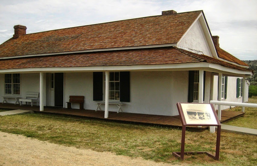
The park contains well-preserved buildings like this one which served as the bachelor officers quarters.

Next they moved on to Montezuma Castle National Monument. This 20 room 'apartment house' was built and occupied by the Sinagua people between 1100 and 1400 (and given a very strange name somewhere along the way.)

Even more interesting to me is Montezuma Well.  Here is an explanation from the National Park website.

Montezuma Well, a unit of Montezuma Castle, is located 11 miles from the park. Formed long ago by the collapse of a limestone cavern, over one million gallons of water a day flows continuously into the Well. This constant supply of warm, fresh water provides an aquatic habitat like no other in the world, and has served as an oasis for wildlife and humans for thousands of years.

The Sinagua created irrigation ditches, sections of which are still used today by nearby residents for gardens and livestock. (Not this section obviously.)

I'm sure there were a few 'Eek's when the WINs came upon this guy.  Looks like a rattler to me.

Last was a stop at V Bar V Heritage Site - location of the largest known collection of petroglyphs in the Verde Valley.

Although the real meaning of petroglyphs is known only to the people who made them, it is believed that these particular etchings were used as calendars.  By watching the movement of sunlight across the rock images, the ancient people knew when to plant and harvest crops or when to begin certain ceremonies.

I mentioned in a previous post that we took a car trip to Prescott to visit our friend Carol.  I forgot to post the only picture I took on that trip which was with my phone.  Watson Lake is unbelievably scenic.
Almost makes me wish I had kept my kayak.

This concludes our time in Sedona/Cottonwood area.  Funny thing - anybody who has been to Sedona knows the popular shopping area called Tlaquepaque.  Although I am not a shopper, I understand it is really something to see and I still haven't been there.  Oh well, there's always next time.