On September 30th, we spent a very busy day seeing the sights around Mammoth Lakes. We took off bright and early (actually, not that early) and drove the Mammoth Scenic Loop Road which takes off from US 395 just south of our campground. It's not really that scenic, but it is a shortcut to where we were going.
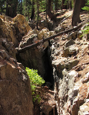
Our first stop was Earthquake Fault - how can you resist something like that?
As the sign explained, a more precise name would be Earthquake Fissure, because the sides of this 10 foot wide, 60 foot deep crevasse have not moved much in relation to each other.
Someday the magma might rise to the surface, but it also might just fill up with debris.
Next stop was the Minaret Vista viewpoint, a place that deserves the viewpoint designation. Pretty.
Then it was on to Devils Postpile National Monument. Luckily, again, we went on September 30th just before the shutdown.
As basalt lava erupts from volcanic vents and cools, it shrinks and cracks. At Devils Postpile, this process formed amazing vertical columns.
The sign didn't explain why some of the columns are not exactly vertical. I guess some shifting occurred during the cooling process.
You can also hike up to the top. On the way, we got a closer look at this interesting bit of geology.
Maybe the most interesting part is the top which was worn smooth by glaciers into a patio-like appearance.
The columns have various numbers of sides.
Next we drove to the Rainbow Falls trailhead. I missed the falls on my last visit, so I was excited to see it. From the trail, we could see some of the area that burned in the 1990s. It's interesting to see the land come back from something like that.
Over the years, the river cut though the lava flow . . .
And formed pretty Rainbow Falls.
We were there about 1:30 and I think that was a little early for full rainbow effect. We did see a bit of color in the mist.
Every once in awhile, we have to play tourist and take our picture in front of a natural wonder. In my case, I just wonder how to get rid of hat hair.
On our return hike, we noticed this lovely spot for a picnic. I wonder why nobody is using it.
We also checked out a few of the lakes around Mammoth Lakes. This is Twin Lakes taken from the top of Twin Falls. There wasn't much water going over the falls at this time, but it drops 300 feet from Lake Mamie to Twin Lakes.
And we drove around pretty Lake Mary.
We did all this plus hit McDonalds for lunch and were still home by 5 o'clock.


Quite a hike! Did you check to see if there were any picnickers under that tree? ;c)
ReplyDeleteHope you can enjoy your travels without getting locked up by a park rangers for being someplace you shouldn't be...
Those columns are really strange looking but cool. Glad you got to see some of the views before the shut down.
ReplyDeleteWith Devils Postpile being a National Monument I am surprised it was not barricaded off too. I have seen that they are having some areas which get no federal funds at all close down, even some which are supported totally by admission and donations. Honestly, this all just stinks to high heavens. --Dave
ReplyDeleteThat's a great picture. I suggest you use it for Christmas. I don't see evidence of hat hair.
ReplyDeleteThose basaltic columns look just like some we went to see a few days ago here in Iceland.
ReplyDeleteI have a lot of catching up to do on my blog reading, but I wanted to answer your question about the "blue bubble" and if it was erupting through ice.
Looks to the contrary, that is not just ice but the color of the water just before the geyser erupts. I know the formation of the bubble has something to do with the shape of the hole constricting the eruption when it first begins to form. The color is probably a combination of the minerals in the water, and the refraction of blue in the color spectrum (similar to glaciers), but I need to do a bit more research about that.
Are you sure those columns weren't cut by ancient aliens? Such precision! Love the waterfall!!
ReplyDelete